


 |
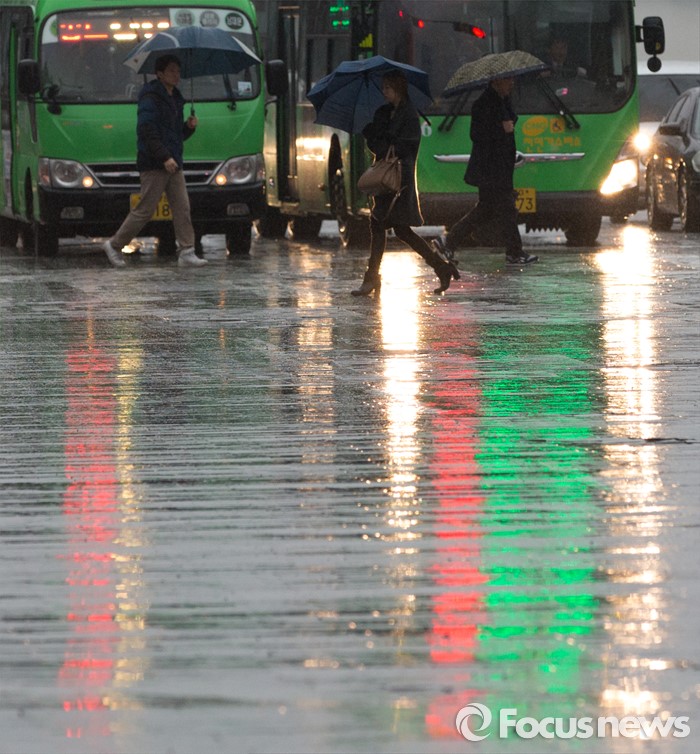
| △ 비 내리는 광화문광장 |
(서울=포커스뉴스) 금요일인 4일은 동해상에 위치한 고기압의 가장자리에 들다가 중국 중부지방에서 북동진하는 기압골의 영향을 받아 전국에 구름이 많다가 차차 흐려지겠다.
기상청에 따르면 오전에 남해안에서 비(강수확률 60~70%)가 내리기 시작해 오후에는 충청이남지방, 밤에는 그 밖의 중부지방 등으로 점차 비가 확대되겠다.
강원 동해안과 울릉도·독도를 제외한 전국에는 20~60㎜의 비가 내릴 것으로 보인다.
특히 제주도산간과 지리산 부근, 전남 남해안 등에는 80㎜ 이상의 비가 내릴 것으로 예상된다.
오전 최저기온은 1~10도, 오후 최고기온은 8~17도 등이 되겠다.
바다의 물결은 전해상에서 0.5~2.0m로 일겠다.
기상청 관계자는 “기온이 높은 가운데 4일부터 6일 사이에 다소 많은 비가 내리면서 얼었던 지반이 녹아 낙석과 축대붕괴 등 해빙기 안전사고의 위험이 있겠으니 유의하기 바란다”고 당부했다.
지역별 날씨3월 4일(금요일)서울흐리고 오후에 비7~15℃강수 확률 30~70%춘천흐려져 비2~16℃30~60%강릉차차 흐려짐3~10℃20~30%대전흐려고 오후에 비7~17℃30~70%청주흐려져 비6~16℃20~70%대구흐려고 오후에 비6~17℃30~70%전주흐리고 오후에 비7~17℃30~70%광주흐리고 비9~17℃70%부산흐리고 비10~16℃60%제주흐리고 비 후 갬8~16℃20~60%울릉·독도구름많음7~11℃20%자료: 기상청.focus_w_t_box:after, .focus_w_t_wrapper:after{clear:both;display:block;content:"";}.focus_w_t_wrapper {list-style:none;max-width:700px; padding:0px;margin:0px;margin:auto;position:relative; position: relative !important;top: 0px !important;left: 0px !important;height:auto !important;}.focus_w_t_wrapper li{width:49%;max-width:174px;float:left;border:1px solid RGB(199, 199, 199);margin-left:-1px;margin-top:-1px;position: relative;height:132px !important;vertical-align: top;cursor: pointer; }.focus_w_t_m, .focus_w_t_m_1, .focus_w_t_m_2{ table-layout: fixed;width:100%;height:132px;border-collapse: collapse; font-family: 나눔고딕, NanumGothic, sans-serif; background-color:white;}.focus_w_t_m_1 td, .focus_w_t_m_2 td{ text-align:center; }.focus_w_t_m td{text-align:center;}.focus_w_t_m_1 .focus_tit, .focus_w_t_m_2 .focus_tit{background-color:rgb(81, 143, 187); color:white;font-weight:bold;height:29px;}.focus_w_t_m {background-color:rgb(225, 225, 225);}.focus_w_t_m_2{background-color:rgb(235, 235, 235);}.focus_p{background-color:rgb(235, 235, 235);color:rgb(102, 102, 102);font-weight:bold;border-top:1px solid RGB(199, 199, 199);}.focus_temp{font-weight:bold;}김인철 기자
[저작권자ⓒ 부자동네타임즈. 무단전재-재배포 금지]